Photo Taken Date: unknown
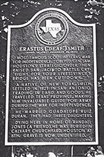
Main Name: Deaf Smith Grave | FB-C152
Alternate Names:
- None
Access: There is public access to the cemetery..
Location: Houston Street, Richmond
NAD83 Coordinates: Latitude: 29 34.805 N, Longitude: 95 45.743 W
Map Coordinates: 29.5800,-95.76238
Status and Other Information: The cemetery status is inactive and it has a Historical Marker. The cemetery is not affiliated with any organizations and the ethnicity is primarily Anglo. The size of the cemetery is unknown. The number of known burials is 1 and the date of the earliest burial is 11/30/1837.