Photo Taken Date: 2013
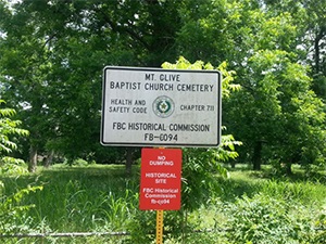
Main Name: Mt. Olive Baptist Church Cemetery | FB-C094
Alternate Names:
- Gibbs Cemetery
- Grover Cemetery
Access: Cemetery access is via PRIVATE property. Permission from the land owner MUST be obtained prior to visiting the cemetery.
Location: Hagerson Rd, Missouri City
NAD83 Coordinates: 29 32.236 N, 95 34.380 W
Map Coordinates: 29.537267, -95.573000
Status and Other Information: The cemetery status is inactive. The cemetery is affiliated with a religious organization and the ethnicity is primarily Afro-American. The size of the cemetery is 1.13 acres. The number of burials is unknown and the date of the earliest burial is 1989.
View Mt. Olive Baptist Church Cemetery | FB-C094 in a larger map