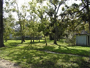
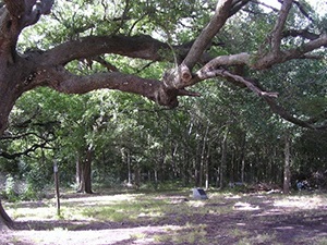
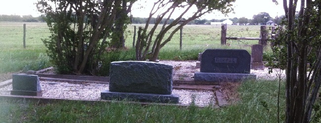
Croom Cemetery

Photo Taken Date: 1994

Willie Jones Cemetery | FB-C132

Main Name: Jones Cemetery, Willie | FB-C132

Alternate Names:

  • Richmond-Foster Road Cemetery
  • Croom Cemetery

Access: There is public access to the cemetery.

Location: Near Foolish Pleasure Court, Richmond

NAD83 Coordinates: Latitude: 29 36.716 N, Longitude: 95 46.150 W

Map Coordinates: 29.61193,-95.76917

Status and Other Information: The cemetery status is inactive. The cemetery is affiliated with a religious organization and the ethnicity is primarily Afro-American. The size of the cemetery is 2.9 acres. The number of burials is 64 and the date of the earliest burial is 17 June, 1903.

>


Craven – Ellis Cemetery | FB-C058

Main Name: Craven – Ellis Cemetery | FB-C058

Alternate Names:

  • Stafford City Cemetery
  • Stafford Colored Cemetery

Access: Public

Location: Stafford Road, Stafford

NAD83 Coordinates: 29 37.493 N, 95 33.110 W

Map Coordinates: 29.624883, -95.551833

Status and Other Information: The cemetery status is active.  The cemetery is not affiliated with any organizations and has no primary ethnicity.  The size of the cemetery is 3.57 acres.  The number of known burials is 176 and the date of the earliest burial is 1901.


View Craven – Ellis Cemetery - FB-C058 in a larger map


Crabb River Road Cemetery

Main Name: Dickson-Murfey Cemetery | FB-C069

Alternate Names:

  • Crabb River Road Cemetery
  • Dickson Cemetery

Access: Public

Location: Crabb River Road, Crabb

NAD83 Coordinates: 29 33.470 N, 95 41.341 W

Map Coordinates: 29.557833, -95.689017

Status and Other Information: The cemetery status is inactive. The cemetery is not affiliated with any organizations and the ethnicity is primarily Afro-American. The size of the cemetery is 1.0 acre. The number of known burials is 34 the date of the earliest burial is November 1914.


View Dickson-Murfey Cemetery - FB-C069 in a larger map

Cottonwood Church Cemetery | FB-C026

Main Name: Cottonwood Church Cemetery | FB-C026

Alternate Names:

  • Cottonwood Cemetery
  • St. John’s United Church of Christ

Access: There is public access to the cemetery.

Location: Madden Road, Clodine

NAD83 Coordinates: 29 39.390 N, 95 42.409 W

Map Coordinates: 29.656500, -95.706817

Status and Other Information: The cemetery status is active.  The cemetery is affiliated with a religious organization and the ethnicity is primarily Afro-American.  The size of the cemetery is 1.91 acres.  The number of known burials is 183 and the date of the earliest burial is 06/10/1914.


View Cottonwood Church Cemetery - FB-C026 in a larger map


Concord Cemetery | FB-C012

Photo Date: 2011

Main Name: Concord Cemetery | FB-C012

Alternate Name: Mennonite Cemetery

Access: Public

Location: Fairchilds Road, Fairchilds

NAD83 Coordinates: 29 26.715 N, 95 45.765 W

Map Coordinates: 29.445250, -95.762750

Status and Other Information: The cemetery status is inactive. The cemetery is not affiliated with any organizations and the ethnicity is primarily Afro-American. The size of the cemetery is 1.32 acres. The number of known burials is 24 and the date of the earliest burial is 02/01/1888.


View Concord Cemetery - FB-C012 in a larger map


Community Cemetery, Rosenberg | FB-C052

Main Name: Community Cemetery, Rosenberg | FB-C052

Alternate Names:

  • Bird Cemetery
  • Byrd Cemetery
  • Rosenberg Cemetery
  • Rosenberg City Cemetery

Access: Public

Location: 310 Blume Road, Rosenberg

NAD83 Coordinates: 29 32.342 N, 95 49.604 W

Map Coordinates: 29.539033, -95.826733

Status and Other Information: The cemetery status is active.  The cemetery is not affiliated with any organizations and the ethnicity is primarily Afro-American.  The size of the cemetery is 2.0 acres.  The number of known burials is 209 and the date of the earliest burial is 02/16/1927.


View Community Cemetery, Rosenberg - FB-C052 in a larger map


Community Cemetery, Arcola | FB-C057

Main Name: Community Cemetery, Arcola | FB-C057

Alternate Names:

  • Arcola Community Cemetery
  • Sienna Plantation Cemetery

Access: Cemetery access is via PRIVATE property.  Permission from the land owner MUST be obtained prior to visiting the cemetery.

Location: Near Scanlan Rd, Arcola

NAD83 Coordinates: 29 28.687 N, 95 29.182 W

Map Coordinates: 29.478117, -95.486367

Status and Other Information: The cemetery status is inactive.  The cemetery is affiliated with a religious organization and has no primary ethnicity.  The size of the cemetery is 1.75 acres.  The number of known burials is 3 and the date of the earliest burial is 1921.


View Community Cemetery, Arcola - FB-C057 in a larger map


Community Cemetery

Main Name: Varney-Packer Family Cemetery | FB-C017

Alternate Names:

  • Community Cemetery
  • Packer Cemetery
  • Packer Family Cemetery
  • Stafford Cemetery
  • Varney Cemetery

Access: Public

Location: Packer Lane, Stafford

NAD83 Coordinates: 29 35.866 N, 95 33.168 W

Map Coordinates: 29.597767, -95.552800

Status and Other Information: The cemetery status is active. The cemetery is not affiliated with any organizations and has no primary ethnicity. The size of the cemetery is 2.63 acres. The number of known burials is 23 and the date of the earliest burial is 04/13/1985.


View Varney-Packer Family Cemetery - FB-C017 in a larger map


Community Cemetery

Main Name: Hatton – Ross Cemetery | FB-C086

Alternate Names:

  • Colony Cemetery
  • Community Cemetery

Access: Cemetery access is via PRIVATE property. Permission from the land owner MUST be obtained prior to visiting the cemetery.

Location: Hatton Road, Orchard

NAD83 Coordinates: 29 37.342 N, 96 00.801 W

Map Coordinates: 29.622367, -96.013350

Status and Other Information: The cemetery status is active. The cemetery is not affiliated with any organizations and the ethnicity is primarily Afro-American. The size of the cemetery is 0.61 acres. The number of known burials is 27 and the date of the earliest burial is 10/20/1917.


View Hatton – Ross Cemetery - FB-C086 in a larger map

Colony Cemetery

Main Name: Hatton – Ross Cemetery | FB-C086

Alternate Names:

  • Colony Cemetery
  • Community Cemetery

Access: Cemetery access is via PRIVATE property. Permission from the land owner MUST be obtained prior to visiting the cemetery.

Location: Hatton Road, Orchard

NAD83 Coordinates: 29 37.342 N, 96 00.801 W

Map Coordinates: 29.622367, -96.013350

Status and Other Information: The cemetery status is active. The cemetery is not affiliated with any organizations and the ethnicity is primarily Afro-American. The size of the cemetery is 0.61 acres. The number of known burials is 27 and the date of the earliest burial is 10/20/1917.


View Hatton – Ross Cemetery - FB-C086 in a larger map

Subscribe to Historical Commission