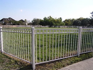
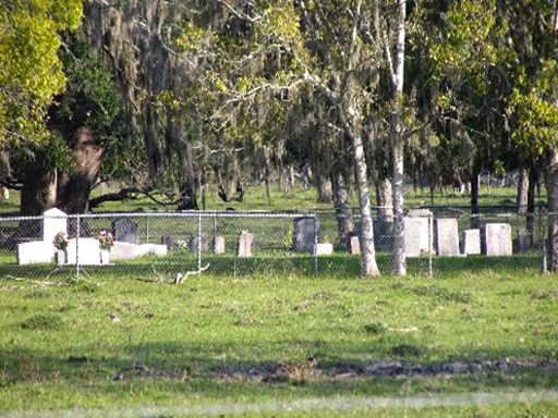
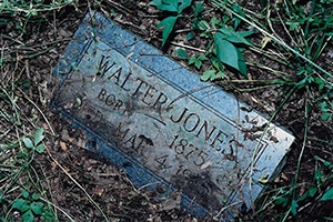
Community Cemetery

Main Name: Varney-Packer Family Cemetery | FB-C017

Alternate Names:

  • Community Cemetery
  • Packer Cemetery
  • Packer Family Cemetery
  • Stafford Cemetery
  • Varney Cemetery

Access: Public

Location: Packer Lane, Stafford

NAD83 Coordinates: 29 35.866 N, 95 33.168 W

Map Coordinates: 29.597767, -95.552800

Status and Other Information: The cemetery status is active. The cemetery is not affiliated with any organizations and has no primary ethnicity. The size of the cemetery is 2.63 acres. The number of known burials is 23 and the date of the earliest burial is 04/13/1985.


View Varney-Packer Family Cemetery - FB-C017 in a larger map


Community Cemetery

Main Name: Hatton – Ross Cemetery | FB-C086

Alternate Names:

  • Colony Cemetery
  • Community Cemetery

Access: Cemetery access is via PRIVATE property. Permission from the land owner MUST be obtained prior to visiting the cemetery.

Location: Hatton Road, Orchard

NAD83 Coordinates: 29 37.342 N, 96 00.801 W

Map Coordinates: 29.622367, -96.013350

Status and Other Information: The cemetery status is active. The cemetery is not affiliated with any organizations and the ethnicity is primarily Afro-American. The size of the cemetery is 0.61 acres. The number of known burials is 27 and the date of the earliest burial is 10/20/1917.


View Hatton – Ross Cemetery - FB-C086 in a larger map

Colony Cemetery

Main Name: Hatton – Ross Cemetery | FB-C086

Alternate Names:

  • Colony Cemetery
  • Community Cemetery

Access: Cemetery access is via PRIVATE property. Permission from the land owner MUST be obtained prior to visiting the cemetery.

Location: Hatton Road, Orchard

NAD83 Coordinates: 29 37.342 N, 96 00.801 W

Map Coordinates: 29.622367, -96.013350

Status and Other Information: The cemetery status is active. The cemetery is not affiliated with any organizations and the ethnicity is primarily Afro-American. The size of the cemetery is 0.61 acres. The number of known burials is 27 and the date of the earliest burial is 10/20/1917.


View Hatton – Ross Cemetery - FB-C086 in a larger map

Cole Land Grant Cemetery | FB-C160

Photo Taken Date: 2016

Cole Land Grant Cemetery | FB-C160

Main Name: Cole Land Grant Cemetery | FB-C160

Alternate Names:

  • None

Access: Cemetery access is via PRIVATE property. Permission from the land owner MUST be obtained prior to visiting the cemetery.

Location: Near Battle Rd, Kendleton

NAD83 Coordinates: 29 29.129 N,96 03.446 W

Map Coordinates: 29.48549,-96.05744

Status and Other Information: The cemetery status is inactive. The cemetery is not affiliated with any organizations and has no primary ethnicity. The size of the cemetery is unknown. The number of known burials is 1 and the date of the earliest burial is 05/01/1981.

History: Work In Progress

Coffmann Family Cemetery | FB-C051

Main Name: Coffmann Family Cemetery | FB-C051

Alternate Names:

  • Cobbins Cemetery
  • Koffman Cemetery

Access: Cemetery access is via PRIVATE property.  Permission from the land owner MUST be obtained prior to visiting the cemetery.

Location: Fairway Drive, Richmond

NAD83 Coordinates: 29 34.258 N, 95 45.350 W

Map Coordinates: 29.570967, -95.755833

Status and Other Information: The cemetery status is active. The cemetery is not affiliated with any organizations and the ethnicity is primarily Afro-American. The size of the cemetery is 0.07 acres. The number of known burials is 13 and the date of the earliest burial is 1948.


View Coffmann Family Cemetery - FB-C051 in a larger map


Cockburn Plantation Cemetery | FB-C159

Main Name: Cockburn Plantation Cemetery | FB-C159

Alternate Names:   

  • None

Access: There is public access to the cemetery.

Location: Near Brazos River and SH99, Sugar Land

NAD83 Coordinates: 29 34.671 N, 95 40.720 W

Map Coordinates: 29.57778,-95.67872

Status and Other Information: The cemetery status is inactive. The cemetery is not affiliated with any organizations and the ethnicity is primarily unknown. The size of the cemetery is unknown. The number of known burials is 5 and the date of the earliest burial is 01/01/1996.


View Gaston Cemetery - FB-C059 in a larger map

Cobbins Cemetery

Main Name: Coffmann Family Cemetery | FB-C051

Alternate Names:

  • Cobbins Cemetery
  • Koffman Cemetery

Access: Cemetery access is via PRIVATE property.  Permission from the land owner MUST be obtained prior to visiting the cemetery.

Location: Fairway Drive, Richmond

NAD83 Coordinates: 29 34.258 N, 95 45.350 W

Map Coordinates: 29.570967, -95.755833

Status and Other Information: The cemetery status is active. The cemetery is not affiliated with any organizations and the ethnicity is primarily Afro-American. The size of the cemetery is 0.07 acres. The number of known burials is 13 and the date of the earliest burial is 1948.


View Coffmann Family Cemetery - FB-C051 in a larger map


Clay Grave, Leonard Jr. | FB-C049

Main Name: Clay Grave, Leonard Jr. | FB-C049

Alternate Names:

  • Clay Grave

Access: Cemetery access is via PRIVATE property. Permission from the land owner MUST be obtained prior to visiting the cemetery.

Location: Near Wallis Street, Fulshear

NAD83 Coordinates: 29 41.735 N, 95 54.440 W

Map Coordinates: 29.695383, -95.907333

Status and Other Information: The cemetery status is inactive.  The cemetery is not affiliated with any organizations and has no primary ethnicity.  The size of the cemetery is 0.02 acres.  The number of burials is 1.


View Clay Grave, Leonard Jr. - FB-C049Untitled in a larger map


Clay Grave

Main Name: Clay Grave, Leonard Jr. | FB-C049

Alternate Names:

  • Clay Grave

Access: Cemetery access is via PRIVATE property. Permission from the land owner MUST be obtained prior to visiting the cemetery.

Location: Near Wallis Street, Fulshear

NAD83 Coordinates: 29 41.735 N, 95 54.440 W

Map Coordinates: 29.695383, -95.907333

Status and Other Information: The cemetery status is inactive.  The cemetery is not affiliated with any organizations and has no primary ethnicity.  The size of the cemetery is 0.02 acres.  The number of burials is 1.


View Clay Grave, Leonard Jr. - FB-C049Untitled in a larger map


Cesinger-Seiler Cemetery | FB-C011

Main Name: Cesinger-Seiler Cemetery | FB-C011

Alternate Names:

  • Cesinger Cemetery
  • Emmanuel Cemetery
  • German Evangelical Cemetery
  • Prairie Mound Cemetery
  • Seiler Cemetery

Access: Public

Location: Roesler Road, Fairchilds

NAD83 Coordinates: 29 24.643 N, 95 46.795 W

Map Coordinates: 29.410717, -95.779917

History: Cesinger-Seiler Cemetery | FB-C011 [PDF]

Status and Other Information: The cemetery status is active and it has a Historical Marker. The cemetery is not affiliated with any organizations and the ethnicity is primarily Anglo. The size of the cemetery is 0.96 acres. The number of known burials is 65 and the date of the earliest burial is 10/16/1894.


View Cesinger-Seiler Cemetery - FB-C011 in a larger map


Subscribe to Historical Commission