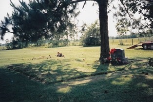
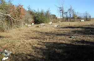
Paradise Garden Cemetery

Main Name: Kendleton Cemetery | FB-C077

Alternate Names:

  • Oak Hill Baptist Cemetery
  • Paradise Garden Cemetery

Access: Public.

Location: Lum Rd, Kendleton

NAD83 Coordinates: 29 26.371 N, 96 00.052 W

Map Coordinates: 29.439517, -96.000867

Status and Other Information: The cemetery status is active. The cemetery is not affiliated with any organizations and the ethnicity is primarily Afro-American. The size of the cemetery is 1.16 acres. The number of burials is unknown and the date of the earliest burial is 10/04/1997.


View Kendleton Cemetery - FB-C077 in a larger map

Pageville Baptist Church Grave

Main Name: Page’s Chapel Grave | FB-C064

Alternate Names:

  • Pageville Baptist Church Grave
  • Rev. Ada Page Grave

Access: There is public access to the cemetery.

Location: Clayhead Road, Richmond

NAD83 Coordinates: 29 38.090 N, 95 46.505 W

Map Coordinates: 29.63484, -95.77510

Status and Other Information: The cemetery status is inactive. The cemetery is affiliated with a religious organization and the ethnicity is primarily Afro-American. The size of the cemetery is 0.02 acre. The number of known burials is 1 and the date of the earliest burial is unknown.


View Page’s Chapel Grave - FB-C064 in a larger map

Page’s Chapel Grave | FB-C064

Main Name: Page’s Chapel Grave | FB-C064

Alternate Names:

  • Pageville Baptist Church Grave
  • Rev. Ada Page Grave

Access: There is public access to the cemetery.

Location: Clayhead Road, Richmond

NAD83 Coordinates: 29 38.090 N, 95 46.505 W

Map Coordinates: 29.63484, -95.77510

Status and Other Information: The cemetery status is inactive. The cemetery is affiliated with a religious organization and the ethnicity is primarily Afro-American. The size of the cemetery is 0.02 acre. The number of known burials is 1 and the date of the earliest burial is unknown.


View Page’s Chapel Grave - FB-C064 in a larger map

Packer Family Cemetery

Main Name: Varney-Packer Family Cemetery | FB-C017

Alternate Names:

  • Community Cemetery
  • Packer Cemetery
  • Packer Family Cemetery
  • Stafford Cemetery
  • Varney Cemetery

Access: Public

Location: Packer Lane, Stafford

NAD83 Coordinates: 29 35.866 N, 95 33.168 W

Map Coordinates: 29.597767, -95.552800

Status and Other Information: The cemetery status is active. The cemetery is not affiliated with any organizations and has no primary ethnicity. The size of the cemetery is 2.63 acres. The number of known burials is 23 and the date of the earliest burial is 04/13/1985.


View Varney-Packer Family Cemetery - FB-C017 in a larger map


Packer Cemetery

Main Name: Varney-Packer Family Cemetery | FB-C017

Alternate Names:

  • Community Cemetery
  • Packer Cemetery
  • Packer Family Cemetery
  • Stafford Cemetery
  • Varney Cemetery

Access: Public

Location: Packer Lane, Stafford

NAD83 Coordinates: 29 35.866 N, 95 33.168 W

Map Coordinates: 29.597767, -95.552800

Status and Other Information: The cemetery status is active. The cemetery is not affiliated with any organizations and has no primary ethnicity. The size of the cemetery is 2.63 acres. The number of known burials is 23 and the date of the earliest burial is 04/13/1985.


View Varney-Packer Family Cemetery - FB-C017 in a larger map


Our Lady of Guadalupe Cemetery | FB-C105

Main Name: Our Lady of Guadalupe Cemetery | FB-C105

Alternate Names:

  • Guadalupe Cemetery
  • Pena Cemetery
  • Latin American Cemetery

Access: Public

Location: Ave D, Rosenberg

NAD83 Coordinates: 29 33.895 N, 95 48.892 W

Map Coordinates: 29.564917, -95.814867

Status and Other Information: The cemetery status is active. The cemetery is affiliated with a religious organization and the ethnicity is mixed. The size of the cemetery is unknown. The number of known burials is 2093 and the date of the earliest burial is 08/05/1924.

View Our Lady of Guadalupe Cemetery | FB-C105 in a larger map

Orchard Public Cemetery | FB-C039

Main Name: Orchard Public Cemetery | FB-C039

Alternate Names:

  • Orchard Cemetery

Access: Public

Location: Hwy 36, Orchard

NAD83 Coordinates: Latitude: 29 36.372 N, Longitude: 95 58.975 W

Map Coordinates: 29.606200, -95.982917

Status and Other Information: The cemetery status is active.  The cemetery is not affiliated with any organizations and the ethnicity is primarily Anglo.  The size of the cemetery is 1.94 acres.  The number of known burials is 281 and the date of the earliest burial is 1936.


View Orchard Public Cemetery - FB-C039 in a larger map


Orchard Cemetery

Main Name: Orchard Public Cemetery | FB-C039

Alternate Names:

  • Orchard Cemetery

Access: Public

Location: Hwy 36, Orchard

NAD83 Coordinates: Latitude: 29 36.372 N, Longitude: 95 58.975 W

Map Coordinates: 29.606200, -95.982917

Status and Other Information: The cemetery status is active.  The cemetery is not affiliated with any organizations and the ethnicity is primarily Anglo.  The size of the cemetery is 1.94 acres.  The number of known burials is 281 and the date of the earliest burial is 1936.


View Orchard Public Cemetery - FB-C039 in a larger map


Old Kendleton Cemetery

Main Name: Newman Chapel Cemetery | FB-C048

Alternate Names:

  • Baptist Cemetery
  • Methodist Episcopal Cemetery
  • Old Kendleton Cemetery

Access: Public

Location: Allen Bates Park, Kendleton

NAD83 Coordinates: 29 26.031 N, 96 00.334 W

Map Coordinates: 29.433850, -96.005567

Status and Other Information: The cemetery status is inactive.  The cemetery is affiliated with a religious organization and the ethnicity is primarily Afro-American.  The size of the cemetery is 0.75 acre.  The number of known burials is 18 and the date of the earliest burial is 05/13/1882.


View Newman Chapel Cemetery - FB-C048 in a larger map


Old Jones Cemetery, Jones Cemetery

Photo Taken Date: 2012

old-JOnes

Main Name: White Cemetery | FB-C167

Alternate Names:

  • Old Jones Cemetery, Jones Cemetery

Access: Cemetery access is via PRIVATE property. Permission from the land owner MUST be obtained prior to visiting the cemetery.

Location: Near Bellaire Blvd, Rosenberg

NAD83 Coordinates: 29 40.819 N, 95 47.481 W

Map Coordinates: 29.68032, -95.79135

Status and Other Information:

The cemetery status is inactive. The cemetery is not affiliated with any organizations and the ethnicity is primarily Anglo. The size of the cemetery is 0.10 acre. The number of known burials is 12 and the date of the earliest burial is 05/05/1903.

Subscribe to Historical Commission