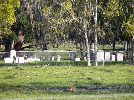
Old Jones Cemetery | Alternate FB-C059

Main Name: Gaston Cemetery | FB-C059

Alternate Names:

  • Old Jones Cemetery

Access: Cemetery access is via PRIVATE property.  Permission from the land owner MUST be obtained prior to visiting the cemetery.

Location: Briscoe Road, Rosenberg

NAD83 Coordinates: 29 40.817 N, 95 46.482 W

Map Coordinates: 29.680250, -95.791367

Status and Other Information: The cemetery status is inactive.  The cemetery is not affiliated with any organizations and the ethnicity is primarily Anglo.  The size of the cemetery is 0.1 acre.  The number of known burials is 12 and the date of the earliest burial is 05/05/1903.


View Gaston Cemetery - FB-C059 in a larger map


Old Jones Cemetery | Alternate FB-C020
Sansbury Cemetery | FB-C020

Photo Date: 2011

Main Name: Sansbury Cemetery | FB-C020

Alternate Names:

  • Sandberry Cemetery
  • Sansberry Cemetery
  • Stansberry Cemetery
  • Old Jones Cemetery

Access: Public

Location: Crabb River Road, Crabb

NAD83 Coordinates: 29 32.807 N, 95 41.900 W

Map Coordinates: 29.546783, -95.698333

Status and Other Information: The cemetery status is active. The cemetery is not affiliated with any organizations and the ethnicity is primarily Afro-American. The size of the cemetery is 2.31 acres. The number of known burials is 145 and the date of the earliest burial is 05/19/1896.


View Sansbury Cemetery - FB-C020 in a larger map


Old Imperial Farm Cemetery

Photo Taken Date: 2017

Imperial Farm Cemetery | FB-C121

Main Name: Imperial Farm Cemetery | FB-C121

Alternate Names:

  • Central Unit Cemetery
  • New Addition Cemetery
  • Old Imperial Farm Cemetery
  • State Prison Cemetery
  • Sugar Land Cemetery
  • TDJC Central Unit Cemetery

Access: Cemetery access is via PRIVATE property. Permission from the land owner MUST be obtained prior to visiting the cemetery.

Location: Near Hwy6 and SH-90A, Sugar Land

NAD83 Coordinates: 29 36.314 N, 95 39.440 W

Map Coordinates: 29.605233, -95.657333

Status and Other Information: The cemetery status is inactive and it has a Historical Marker. The cemetery is not affiliated with any organizations and the ethnicity is mixed. The size of the cemetery is unknown. The number of known burials is 35 and the date of the earliest burial is 02/10/1912.

View Imperial Farm Cemetery | FB-C121 in a larger map

Old Guy Cemetery

Photo Taken Date: May 1993

Guy Public Cemetery | FB-C144

Main Name: Guy Public Cemetery | FB-C144

Alternate Names:

  • Old Guy Cemetery
  • Prairie Mound Cemetery

Access: Public

Location: Fm 1964, Guy

NAD83 Coordinates: 29 21.979 N, 95 45.581 W

Map Coordinates: 29.36632,-95.75968


Status and Other Information: The cemetery status is active. The cemetery is not affiliated with any organizations and the ethnicity is primarily Anglo. The size of the cemetery is 4.0 acres. The number of known burials is 350 and the date of the earliest burial is 1900.


View Guy Public Cemetery | FB-C144 in a larger map


Oak Hill Cemetery, Richmond | FB-C103

Main Name: Oak Hill Cemetery, Richmond | FB-C103

Alternate Names: None

Access: Public

Location: 21410 Morton Rd, Richmond

NAD83 Coordinates: 29 40.007 N, 95 45.248 W

Map Coordinates: 29.666783, -95.754133

Status and Other Information: The cemetery status is active and it has a Historical Marker. The cemetery is affiliated with a religious organization and the ethnicity is primarily Afro-American. The size of the cemetery is 1.0 acre. The number of known burials is 144 and the date of the earliest burial is 05/23/1930.

View Oak Hill Cemetery, Richmond | FB-C103 in a larger map

Oak Hill Cemetery, Kendleton | FB-C104

Main Name: Oak Hill Cemetery, Kendleton | FB-C104

Alternate Names: None

Access: Access to the cemetery is via PRIVATE property. Permission from the land owner MUST be obtained prior to visiting the cemetery.

Location: Allen Bates Park, Kendleton

NAD83 Coordinates: 29 26.121 N, 96 00.502 W

Map Coordinates: 29.435350, -96.008367

Status and Other Information: The cemetery status is inactive. The cemetery is affiliated with a religious organization and the ethnicity is primarily Afro-American. The size of the cemetery is 3.43 acres. The number of known burials is 35 and the date of the earliest burial is 11/06/1890.

View Oak Hill Cemetery, Kendleton | FB-C104 in a larger map

Oak Hill Baptist Cemetery

Main Name: Kendleton Cemetery | FB-C077

Alternate Names:

  • Oak Hill Baptist Cemetery
  • Paradise Garden Cemetery

Access: Public.

Location: Lum Rd, Kendleton

NAD83 Coordinates: 29 26.371 N, 96 00.052 W

Map Coordinates: 29.439517, -96.000867

Status and Other Information: The cemetery status is active. The cemetery is not affiliated with any organizations and the ethnicity is primarily Afro-American. The size of the cemetery is 1.16 acres. The number of burials is unknown and the date of the earliest burial is 10/04/1997.


View Kendleton Cemetery - FB-C077 in a larger map

Nix Family Cemetery | FB-C102

Main Name: Nix Family Cemetery | FB-C102

Alternate Names:

  • Nix Cemetery

Access: Public

Location: 219 Fleming St, Richmond

NAD83 Coordinates: 29 34.961 N, 95 46.223 W

Map Coordinates: 29.582683, -95.770383

Status and Other Information: The cemetery status is inactive. The cemetery is not affiliated with any organizations and the ethnicity is primarily Afro-American. The size of the cemetery is 0.07 acre. The number of known burials is 1 and the date of the earliest burial is 1950.

View Nix Family Cemetery | FB-C102 in a larger map

Nix Cemetery

Main Name: Nix Family Cemetery | FB-C102

Alternate Names:

  • Nix Cemetery

Access: Public

Location: 219 Fleming St, Richmond

NAD83 Coordinates: 29 34.961 N, 95 46.223 W

Map Coordinates: 29.582683, -95.770383

Status and Other Information: The cemetery status is inactive. The cemetery is not affiliated with any organizations and the ethnicity is primarily Afro-American. The size of the cemetery is 0.07 acre. The number of known burials is 1 and the date of the earliest burial is 1950.

View Nix Family Cemetery | FB-C102 in a larger map

Newman Chapel Cemetery | FB-C048

Main Name: Newman Chapel Cemetery | FB-C048

Alternate Names:

  • Baptist Cemetery
  • Methodist Episcopal Cemetery
  • Old Kendleton Cemetery

Access: Public

Location: Allen Bates Park, Kendleton

NAD83 Coordinates: 29 26.031 N, 96 00.334 W

Map Coordinates: 29.433850, -96.005567

Status and Other Information: The cemetery status is inactive.  The cemetery is affiliated with a religious organization and the ethnicity is primarily Afro-American.  The size of the cemetery is 0.75 acre.  The number of known burials is 18 and the date of the earliest burial is 05/13/1882.


View Newman Chapel Cemetery - FB-C048 in a larger map


Subscribe to Historical Commission