Main Name: Castelow Farm Cemetery | FB-C082
Alternate Names:
- None
Access: Public
Location: Not located, number assigned by Texas State Historical Commission.
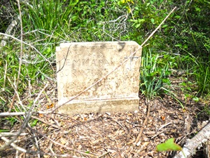
Main Name: Castelow Farm Cemetery | FB-C082
Alternate Names:
Access: Public
Location: Not located, number assigned by Texas State Historical Commission.
Photo Taken Date: May 2012
Main Name: Cartwright-McCrary Cemetery | FB-C040
Alternate Names:
Access: Cemetery access is via PRIVATE property. Permission from the land owner MUST be obtained prior to visiting the cemetery.
Location: Near Bellaire and Canal Rd, Richmond
NAD83 Coordinates: 29 40.510 N, 95 46.504 W
Map Coordinates: 29.675167, -95.775067
Status and Other Information: The cemetery status is inactive. The cemetery is affiliated with a Private Property - Permission from the land owner MUST be obtained prior to visiting the cemetery. organization and the ethnicity is primarily Afro-American. The size of the cemetery is 0.19 acres. The number of known burials is 8 and the date of the earliest burial is 10/13/1920.
View Cartwright-McCrary Cemetery - FB-C040 in a larger map
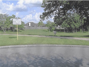
Main Name: Calvary-Sitta Cemetery | FB-C013
Alternate Names:
Access: Public
Location: Foster School Road, Needville
NAD83 Coordinates: 29 26.389 N, 95 50.290 W
Map Coordinates: 29.439817, -95.838167
Status and Other Information: The cemetery status is active. The cemetery is not affiliated with any organizations and the ethnicity is primarily Anglo. The size of the cemetery is 1 acre. The number of known burials is 62 and the date of the earliest burial is 03/25/1905.
View Calvary-Sitta Cemetery - FB-C013 in a larger map
Main Name: Community Cemetery, Rosenberg | FB-C052
Alternate Names:
Access: Public
Location: 310 Blume Road, Rosenberg
NAD83 Coordinates: 29 32.342 N, 95 49.604 W
Map Coordinates: 29.539033, -95.826733
Status and Other Information: The cemetery status is active. The cemetery is not affiliated with any organizations and the ethnicity is primarily Afro-American. The size of the cemetery is 2.0 acres. The number of known burials is 209 and the date of the earliest burial is 02/16/1927.
View Community Cemetery, Rosenberg - FB-C052 in a larger map
Main Name: Burnt Lake Cemetery | FB-C078
Alternate Names:
Access: Public
Location: Not located, number assigned by Texas State Historical Commission.
Main Name: Burnside Cemetery | FB-C158
Alternate Names:Fenn Plantation Cemetery
Cemetery access: Cemetery access is via PRIVATE property. Permission from the land owner MUST be obtained prior to visiting the cemetery.
Location:Federal Way, Sugar Land
NAD83 Coordinates:29 30.227 N, 95 30.061 W
Map Coordinates: 29.50370,-95.50101
Status and Other Information: The cemetery status is inactive. The cemetery is not affiliated with any organizations and has no primary ethnicity. The size of the cemetery is 0.25 acres. The number of known burials is 4 and the date of the earliest burial is unknown.
History: Work In Progress
Main Name: Burnett Estate Cemetery | FB-C038
Alternate Names:
Access: Cemetery access is via PRIVATE property. Permission from the land owner MUST be obtained prior to visiting the cemetery.
Location: 21410 Morton Road, Richmond
NAD83 Coordinates: 29 29.426 N, 96 02.186 W
Map Coordinates: 29.490433, -96.036433
Status and Other Information: The cemetery status is inactive. The cemetery is not affiliated with any organizations and the ethnicity is primarily Afro-American. The size of the cemetery is 1 acre. The number of known burials is 4 and the date of the earliest burial is 03/22/1905.
View Burnett Estate Cemetery - FB-C038 in a larger map
Main Name: Thomas Cemetery, Faithe | FB-C076
Alternate Names:
Access: Public
Location: Collins Rd, Richmond
NAD83 Coordinates: 29 35.235 N, 95 46.325 W
Map Coordinates: 29.587250, -95.772083
View Thomas Cemetery, Faithe - FB-C076 in a larger map