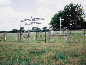
Needville Catholic Cemetery

Main Name: St. Michael’s Catholic Cemetery | FB-C010

Alternate Names:

  • Needville Catholic Cemetery
  • Sitta Cemetery

Access: Public

Location: Main Street, Needville

NAD83 Coordinates: 29 23.791 N, 95 50.121 W

Map Coordinates: 29.396517, -95.835350

Status and Other Information: The cemetery status is active. The cemetery is affiliated with a religious organization and the ethnicity is primarily Anglo. The size of the cemetery is 0.53 acre. The number of known burials is 352 and the date of the earliest burial is 12/09/1906.


View St. Michael’s Catholic Cemetery - FB-C010 in a larger map


Needville Baptist Church Cemetery | FB-C009

Photo Date: 2013

Main Name: Needville Baptist Church Cemetery | FB-C009

Alternate Names:

  • Dipple Cemetery
  • Fink Baptist Cemetery
  • First Baptist Church Cemetery
  • German Baptist Cemetery
  • Maden Cemetery
  • Maiden Cemetery
  • Needville Baptist Cemetery
  • Salem Baptist Cemetery

Access: Public

Location: FM-1236, Needville

NAD83 Coordinates: 29 23.130 N, 95 51.054 W

Map Coordinates: 29.385500, -95.850900

Status and Other Information: The cemetery status is active. The cemetery is affiliated with a religious organization and the ethnicity is primarily Anglo. The size of the cemetery is unknown. The number of known burials is 25 and the date of the earliest burial is 08/12/1899.


View Needville Baptist Church Cemetery - FB-C009 in a larger map


Needville Baptist Cemetery
Needville Baptist Church Cemetery | FB-C009

Photo Date: 2013

Main Name: Needville Baptist Church Cemetery | FB-C009

Alternate Names:

  • Dipple Cemetery
  • Fink Baptist Cemetery
  • First Baptist Church Cemetery
  • German Baptist Cemetery
  • Maden Cemetery
  • Maiden Cemetery
  • Needville Baptist Cemetery
  • Salem Baptist Cemetery

Access: Public

Location: FM-1236, Needville

NAD83 Coordinates: 29 23.130 N, 95 51.054 W

Map Coordinates: 29.385500, -95.850900

Status and Other Information: The cemetery status is active. The cemetery is affiliated with a religious organization and the ethnicity is primarily Anglo. The size of the cemetery is unknown. The number of known burials is 25 and the date of the earliest burial is 08/12/1899.


View Needville Baptist Church Cemetery - FB-C009 in a larger map


Myers Cemetery

Main Name: Dyer-Myers Cemetery | FB-C071

Alternate Names:

  • Myers Cemetery

Access: Public

Location: Fannin Street, Richmond

NAD83 Coordinates: 29 34.659 N, 95 45.427 W

Map Coordinates: 29.577650, -95.757117

Status and Other Information: The cemetery status is inactive and it has a Historical Marker The cemetery is not affiliated with any organizations and has no primary ethnicity. The size of the cemetery is 0.2 acre. The number of known burials is 32 and the date of the earliest burial is 05/09/1919.


View Dyer-Myers Cemetery - FB-C071 in a larger map

Murphy Jones Cemetery | FB-C098

Main Name: Murphy Jones Cemetery | FB-C098

Alternate Names: None

Access: Public

Location: Cemetery Road, Richmond

NAD83 Coordinates: 29 32.708 N, 95 44.325 W

Map Coordinates: 29.545133, -95.738750

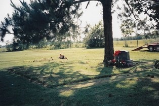
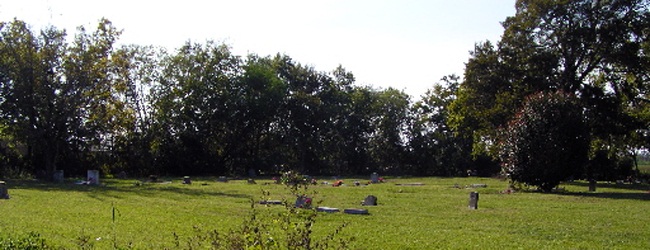
Status and Other Information: The cemetery status is active. The cemetery is not affiliated with any organizations and the ethnicity is primarily Afro-American. The size of the cemetery is 5.09 acres. The number of known burials is 10 and the date of the earliest burial is 1900.

View Murphy Jones Cemetery | FB-C098 in a larger map

Mulberry Cemetery | FB-C097

Photo Taken Date: 2013

Mulberry Cemetery | FB-C097

Main Name: Mulberry Cemetery | FB-C097

Alternate Names:

  • Fields Cemetery 
  • Old St. Phillips Church Cemetery

Access: Access to the cemetery is via PRIVATE property. Permission from the land owner MUST be obtained prior to visiting the cemetery.

Location: Near Sienna Plantation Rd, Missouri City

NAD83 Coordinates: 29 30.954 N, 95 31.681 W

Map Coordinates: 29.515729, -95.528247

Status and Other Information: The cemetery status is inactive. The cemetery is affiliated with a religious organization and the ethnicity is primarily Afro-American. The size of the cemetery is unknown. The number of known burials is 46 and the date of the earliest burial is 12/22/1935.

View Mulberry Cemetery | FB-C097 in a larger map

Mt. Tabor Cemetery

Photo Taken Date: 2009

Mt. Pilgrim Baptist Church | FB-C095

Main Name: Mt. Tabor Baptist Church Cemetery | FB-C096

Alternate Names:

  • Julif Area Cemetry
  • Mt. Tabor Cemetery

Access: Public

Location: 211 Porter Rd, Arcola

NAD83 Coordinates: 29 26.798 N, 95 28.593 W

Map Coordinates: 29.446633, -95.476550

Status and Other Information: The cemetery status is active. The cemetery is affiliated with a religious organization and the ethnicity is primarily Afro-American. The size of the cemetery is 0.27 acres. The number of known burials is 22 and the date of the earliest burial is 07/01/1984.

View Mt. Tabor Baptist Church Cemetery | FB-C096 in a larger map

Mt. Tabor Baptist Church Cemetery | FB-C096

Photo Taken Date: 2009

Mt. Pilgrim Baptist Church | FB-C095

Main Name: Mt. Tabor Baptist Church Cemetery | FB-C096

Alternate Names:

  • Julif Area Cemetry
  • Mt. Tabor Cemetery

Access: Public

Location: 211 Porter Rd, Arcola

NAD83 Coordinates: 29 26.798 N, 95 28.593 W

Map Coordinates: 29.446633, -95.476550

Status and Other Information: The cemetery status is active. The cemetery is affiliated with a religious organization and the ethnicity is primarily Afro-American. The size of the cemetery is 0.27 acres. The number of known burials is 22 and the date of the earliest burial is 07/01/1984.

View Mt. Tabor Baptist Church Cemetery | FB-C096 in a larger map

Mt. Pleasant Cemetery

Main Name: Mt. Pleasant Baptist Church Cemetery | FB-C019

Alternate Name: Mt. Pleasant Cemetery

Access: Public

Location: Jones River Rd, Booth

NAD83 Coordinates: 29 31.549 N, 95 37.478 W

Map Coordinates: 29.525817, -95.624633

Status and Other Information: The cemetery status is active. The cemetery is affiliated with a religious organization and the ethnicity is primarily Afro-American. The size of the cemetery is 3.25 acres. The number of known burials is 178 and the date of the earliest burial is unknown.


View Mt. Pleasant Baptist Church Cemetery - FB-C019 in a larger map


Mt. Pleasant Baptist Church Cemetery | FB-C019

Main Name: Mt. Pleasant Baptist Church Cemetery | FB-C019

Alternate Name: Mt. Pleasant Cemetery

Access: Public

Location: Jones River Rd, Booth

NAD83 Coordinates: 29 31.549 N, 95 37.478 W

Map Coordinates: 29.525817, -95.624633

Status and Other Information: The cemetery status is active. The cemetery is affiliated with a religious organization and the ethnicity is primarily Afro-American. The size of the cemetery is 3.25 acres. The number of known burials is 178 and the date of the earliest burial is unknown.


View Mt. Pleasant Baptist Church Cemetery - FB-C019 in a larger map


Subscribe to Historical Commission