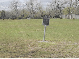
Photos Taken Date: 2015
 |
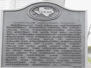 |
Main Name: Needville Methodist Church Cemetery | FB-C151
Alternate Names:
- Zich Cemetery
- Needville German Methodist Cemetery
Access:There is public access to the cemetery.
Location: Needville-Fairchilds Rd, Needville
NAD83 Coordinates: 29° 24.052 N, 95° 48.831 W
Map Coordinates: 29.40097, -95.81385
Status and Other Information: The cemetery status is active and has a Historical Marker. The cemetery is affiliated with a religious organization and the ethnicity is primarily Anglo. The size of the cemetery is unknown. The number of known burials is 18 and the date of the earliest burial is 12/13/1903.
History: Work In Progress
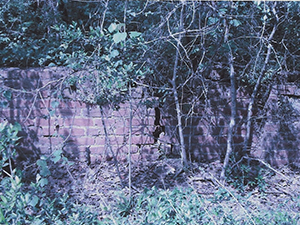
Photo Taken Date: 2009
Main Name: Zemanek Cemetery | FB-C134
Alternate Names:
- None
Cemetery Access: There is public access to the cemetery.
Location: Brumbelow Zemanek Rd, Guy
NAD83 Coordinates: 29 22.889 N, 95 44.612 W
Map Coordinates: 29.38148,-95.74354
Status and Other Information: The cemetery status is inactive. The cemetery is not affiliated with any organizations and the ethnicity is primarily Anglo. The size of the cemetery is 1.0 acre. The number of known burials is 14 and the date of the earliest burial is 28 April, 1912.
Main Name: Rosenberg City Cemetery | FB-C002
Alternate Names:
- W.O.W. Cemetery
- Woodman of the World Cemetery
Access: There is public access to the cemetery.
Location: Ave D, Rosenberg
NAD83 Coordinates: 29 33.819 N, 95 48.822 W
Map Coordinates: 29.563649, -95.813702
Status and Other Information: The cemetery status is active and it has a Historical Marker. The cemetery is not affiliated with any organizations and the ethnicity is mixed. The size of the cemetery is 9.45 acres. The number of known burials is 3,041 and the date of the earliest burial is 09/12/1910.
View Rosenberg City Cemetery - FB-C002 in a larger map
Main Name: Stafford Family Cemetery | FB-C119
Alternate Names:
- Adams Cemetery
- Stafford Cemetery
- William J. Stafford Cemetery
- William J. Stafford Family Cemetery
Access: Access to the cemetery is via PRIVATE property. Permission from the land owner MUST be obtained prior to visiting the cemetery.
Location: Avenue E, Stafford
NAD83 Coordinates: 29 36.361 N, 95 35.163 W
Map Coordinates: 29.606017, -95.586050
Status and Other Information: The cemetery status is inactive. The cemetery is not affiliated with any organizations and the ethnicity is primarily Anglo. The size of the cemetery is 0.7 acre. The number of known burials is 5 and the date of the earliest burial is unknown.
View Stafford Family Cemetery | FB-C119 in a larger map
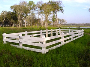
Photo Taken Date: 2014
Main Name: Wilderness Branch Baptist Church Cemetery | FB-C136
Alternate Names:
- None
Access: There is public access to the cemetery
Location: 6207 FM 359, Rosenberg
NAD83 Coordinates: : 29 37.794 N, 95 48.446 W
Map Coordinates: : 29.62990, -95.80743
Status and Other Information: The cemetery status is inactive. The cemetery is affiliated with a religious organization and the ethnicity is primarily Anglo. The size of the cemetery is 0.89 acres. The number of known burials is 6 and the date of the earliest burial is 12/12/1863.
Main Name: Hodge’s Bend Cemetery | FB-C024
Alternate Names:
- White Lake Cemetery
Access: Public
Location: Old Richmond Road, Sugar Land
NAD83 Coordinates: 29 38.446 N, 95 39.741 W
Map Coordinates: 29.640767, -95.662350
Status and Other Information: The cemetery status is inactive and it has a Historical Marker The cemetery is not affiliated with any organizations and the ethnicity is primarily Anglo. The size of the cemetery is 1.00 acre. The number of known burials is 72 and the date of the earliest burial is 1831.
View Hodge’s Bend Cemetery - FB-C024 in a larger map
Photo Taken Date: 2012
Main Name: White Cemetery | FB-C167
Alternate Names:
- Old Jones Cemetery, Jones Cemetery
Access: Cemetery access is via PRIVATE property. Permission from the land owner MUST be obtained prior to visiting the cemetery.
Location: Near Bellaire Blvd, Rosenberg
NAD83 Coordinates: 29 40.819 N, 95 47.481 W
Map Coordinates: 29.68032, -95.79135
Status and Other Information:
The cemetery status is inactive. The cemetery is not affiliated with any organizations and the ethnicity is primarily Anglo. The size of the cemetery is 0.10 acre. The number of known burials is 12 and the date of the earliest burial is 05/05/1903.
Photo Taken Date: 2013
Main Name: Wheat Family Cemetery | FB-C081
Alternate Names:
- Wheat Cemetery
Access: Cemetery access is via PRIVATE property. Permission from the land owner MUST be obtained prior to visiting the cemetery.
Location: Near FM-361, Fairchilds
NAD83 Coordinates: 29 24.949 N, 95 43.212 W
Map Coordinates: 29.41583, -95.72021
Status and Other Information: The cemetery status is inactive. The cemetery is not affiliated with any organizations and the ethnicity is mixed. The size of the cemetery is 0.01 acres. The number of known burials is 7 and the date of the earliest burial is 03/16/1857.
View Wheat Family Cemetery - FB-C081 in a larger map